This path will take you to the approximate locations of 15 objects that represent ruptures in the history of the Santa Clara campus. These objects represent ruptures in various forms, including war, disease, earthquakes, and economic and cultural shifts.
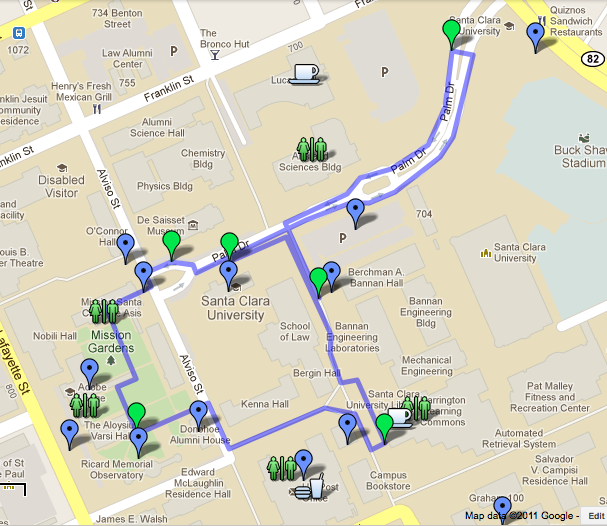 Click here to take our Google Maps Walking Tour!
Or, if you’d like to print out instructions for use on the tour, simply copy the following text and paste it into a word document, and then print it. All of this information is available on the Google Maps walking tour, just organized differently.
PLATFORM 1
People have lived in northern California for more than 10,000 years. The last wave of pre-Contact migrants, the Ohlone, arrived in the Bay area after AD 500. Even before the Spanish colonized California in the late 18th c. AD, the Santa Clara region was culturally diverse — a cosmopolitan mosaic that continues today.
You are standing on a prehistoric graveyard. Many Ohlone people once called this land home.
Take a right on Palm Dr. and continue up the street toward Platform 2.
PLATFORM 2
The Spanish settled in Santa Clara valley in 1771. The area around you was once the third mission site where most of the Santa Clara Native Americans were indoctrinated into European ways of life.
See the historical information plaque in front of you for more information. The cemetery is located to your right, on the north side of Franklin St. The stone outline in this area represents the third mission site quadrangle. To your left, the orchard was located on the far side of Buckshaw Stadium.
Head back down Palm Dr. toward the SCU Mission for Platform 3.
PLATFORM 3
Following the American take over of the California territory in 1847, and the Gold Rush in 1849, hundreds of thousands of people came to the Santa Clara Valley from all over the world. The Spanish and Mexican adobes were replaced with wood frame houses as immigrants began to make a place for themselves in the new U.S. state.
The elevator shaft in O’Connor Hall (to the right of the mission church) contains many artifacts, like the Vichy soda water bottle, that were the refuse of students at the old Santa Clara College. The mission is where Martinelli was once the cantor during mass.
See the historical information plaque in front of you for more information on this area.
When continuing on to Platform 4, head through the Mission Church. Once inside, notice the organ behind you. Be courteous of others if there is a mass (or if you feel uncomfortable, you can go around the Mission by taking the path to your left under the wisteria trellises). Exit the Mission church in the door to the left, just before the nave. On the sidewalk to the left, under the wisteria trellises, is another plaque with historical information. Continue through the courtyard to the south, passing the adobe lodge, until you reach Platform 4 near Varsi Hall.
PLATFORM 4
The late 19th and early 20th century was a complex period filled with wars and pandemics. With these disruptions came major changes in the roles of women, the goals of educational institution, and the organization of labor. Both the campus and student body reveal how these changed played out in the Santa Clara community.
The Adobe Lodge you passed was, and still is, the hangout for SCU’s faculty, including Margaret Chamberlin, the first female member of SCU’s faculty. The ROTC hall, to the west, represents the rifle. Montgomery is survived by the obelisk, which can be found in front of the observatory to the south. The Donohoe Alumni House to the east was once the location of an infirmary that once tended to the needs of ailing members of the Santa Clara community.
Continue down the path to the east, toward Donohoe Alumni House, and follow the map to Platform 5 in front of the SCU Library.
PLATFORM 5
The later portion of the 20th century is characterized by increasing diversity in the campus’ gender, class, and ethnic makeup.
The Multicultural Center (MCC) to the west is the most prominent hub of diversity on campus. Many student organization headquarters can be found there. Past the MCC, the basement level of Benson Center is home to the current headquarters of theRedwood, SCU’s yearbook. Stop in Benson for a bite to eat and the restrooms, or just to experience the hustle and bustle of student life. If you have any questions about SCU, you can ask the people at the Info Desk – just inside Benson and to the right – for information. If you would like to experience SCU’s library, now might also be a good opportunity. To the south, new Graham buildings replace the old ones, recently demolished, that once housed the first female students at SCU.
Head north, back toward the beginning of this tour, to reach the final Platform 6, between Walsh Hall and the new enrollment building.
PLATFORM 6
The radical changes in the 1960’s were, in a way, institutionalized later in the 20th century. This occurred under the presidency of Father Locatelli and under a less homogenous administration that included the likes of Francisco Jimenez.
On Palm Dr. to the left, Walsh Administration building contains the president’s office. This position was once filled by Father Locatelli. On Palm Dr. to the right, a newly constructed admission’s building represents the thousands of students who have been given the opportunity to pursue an education.Francisco Jiménez was the first student to come to SCU from an immigrant background.
We hope you enjoyed the Virtual Santa Clara Ruptures Walking Tour. If you have any questions, comments, or feedback, be sure to leave them on the Comments section of the Virtual Santa Clara website. We look forward to hearing from you, and we hope to use your feedback to better this project.