Life often looks like a giant rose garden beneath a canopy of palm trees for those of us at SCU. This term, we will work together to produce an annotated map of SCU and surrounding locations with pins marking places associated with incarceration and women (and men) who are affected by incarceration. The range of the map will start with our campus and move outward in the general Bay Area — whatever we interpret our locality to mean. Our goal is to make the prison system and its impacts visible as part of our “home” Silicon Valley landscape to: (a) highlight oppressive systems that strive to remain invisible to privileged populations, and (b) to make visible and to humanize our neighbors who are subject to or a part of that system. We will use Google My Maps as our digital tool for building this map because it’s relatively easy to use, everyone at SCU has a Google account, we can collaboratively edit the map, and it’s also easy to make our map public.
How will we research places and events related to incarceration, especially women’s incarceration and criminality, especially if our society works in various ways to keep them hidden? The answer is that we will conduct research in three places and with three types of resources: in the archive in University Library with archival materials, online with digital materials, and in person with experts who share their knowledge with us. There is no correct set of “answers” that I am looking for in this mapping assignment. We are building a map together, the first map of its kind that I know of, that will make visible events and places relating to incarceration and women in and surrounding Santa Clara.
Envision the Final Product
Sources
Here is a Google Doc that contains an evolving list of sources to use for your research. We will keep adding to this list. https://docs.google.com/document/d/1ocnyf1riz-TggKgdNFp357DU-_EngfIEgJefzxBmMig/edit?usp=sharing
Our librarian for our archival work, Kelci Baughman McDowell, published a blog post about the Catholic Women’s Network Newspapers, the source in which you looked for articles by cell mates Jeri Becker and Vonda White. In her blog post, she featured our class (hooray!) and linked to the bibliography that we created with her while we researched. Here is Kelci’s blog post, and here is the bibliography that we made as a class, published in RefWorks.
What Place Will You Map?
When you have picked a place to map, or if you want to add a second place, enter that information in this Google Sheet (must use SCU login to access): https://docs.google.com/spreadsheets/d/1OyeRJsAyzpvRgAiXvOHjXIxS7Kxcx9XWTc0QAcFNiFU/edit?usp=sharing
In the columns next to your place, you will enter the latitude and longitude for your marker by pulling these from the URL in Google Maps, as I demonstrated in class.
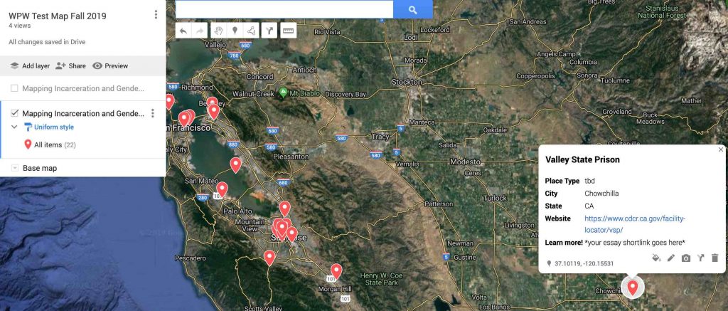
Layers of Place Type: You will also determine the type of place that you are mapping. We have several place types, including: incarceration facilities, support programs, event locations, and historical markers. Each type will have its own unique icon on the map. By assigning a type to each place in our spreadsheet, we can then create layers in our map that show all or some of the selected types. For example, our map could show only prisons; just prisons and support programs for for released folks; just current support programs as well as historical markers; or all of our layers of place types at once. If you’ve never seen this before, check out this short video about markers in Google Maps. Note: in the video, the narrator adds markers by hand. Our method is different: we’re adding them by uploading spreadsheets of our data so that our markers and layers maintain consistency in our data set.
Sharing Our Map
When our map is complete (or as complete as we can make it by the end of our too-short Fall term), we will share it with the public. But which public audience should we focus on? And how? As a class, we will discuss different social media strategies for sharing our map and weigh the pros and cons of these strategies, considering the benefits and drawbacks of different social media outlets and additional factors like labor, account maintenance, reach, and audience. For example, might we want to partner with the NCIP to see if they will Tweet out our map? Might we want to submit our map to College Notes as a project to highlight in their newsletter? What other options are there?
Maintaining Our Map & Planning for Project “End of Life”
Angela Davis asks us to imagine a world without prisons. Can we also imagine a world in which Google no longer supports Google Maps, and our map within that? Digital scholarly projects, like this one, require that we plan for the future of the project. The lifespan of this project can outlive our Fall term together if we want it to. Since as a class we are the map’s co-editors, it is our responsibility to design a sustainability plan as well as an “end-of-life” or “retirement” care plan for our project.
- What happens to the map after we publish it and share it publicly?
- Will we continue to add to the map? Should I invite students in this course next year to contribute to it? Or would you prefer that this map remains the work of this set of co-editors. (Will you accept new co-editors?)
- Who is in charge of maintaining the map, and for how long?
- What will be its death date? When should we take the map down? Who’s job is this? (I bet you’re all looking at me, the teacher, but I’m not your only option.)
- After we take the map down, do we want to preserve its data in some fashion? Someone might keep a local file, or perhaps there’s a way to preserve the map in SCU Archives and Special Collections?
- Is it okay to simply let this project “die” and not preserve it somehow? What do you think?
Project Build Details
- Each student will be responsible for adding at least 1 marker to the map. You can add more than 1. (Quality is more important than quantity.)
- Each marker will show a few descriptive annotations: (1) Name, (2) lat/long, (3) brief description (~10 words), and (4) a link to a Google Doc where you elaborate on the brief description and more fully detail the importance of the place and event you marked on the map.
- For #4 in the above bullet point, you will create a Google Doc that uses text, image, sound, and/or video to describe and detail the importance of the place you have marked on the map. This Google Doc will be linked to your annotated map marker. Your Google Doc description should err on the side of a full, rich description and reflection rather than brevity. Help an audience understand, in text and other media, what a place is, what events it may be linked to, why is it important to mark on a map making incarceration visible in places of privilege like SCU’s campus, what does it look like “on the ground,” what does it sound like (you can make a recording!), what does it smell like or what is the “vibe” of the place. If the place is near enough and you can get there, you might make a short video with your phone to record it and embed that in your doc.
- At the end of your Google Doc (#4 above), you will create a works cited and resources consulted list of the sources you used to find and to describe this place, including the people you talked to.
- At the end of your Google Doc (#4 above), you will also create a bulleted list of related places on our map and link to them, so that your Google Doc place description does not “dead-end” a user but sends them to other content on our map. We want to keep an audience’s attention on the map for as long as we can.
Examples of Annotated Google Maps
Here are a few examples of annotated Google Maps. Our map will share some traits with these but will also be unique to our project. I will continue to add examples as I find them.
- SF Bay Area Sounds Map: http://sfbaysoundmap.com/#
- Map of books owned by Francis Stainforth https://www.google.com/maps/d/viewer?mid=1gj8m90tlwP7zXTTFiyPTQrX9sueywyeQ&usp=sharing (this example is from my own research project)
- THE WALKING DEAD GOOGLE MAP – https://www.google.com/maps/d/viewer?mid=1EIyl56n4fzRrSD1sMMjfTlug_i4&usp=sharing
Process and Due Dates for Project Phases
We will work on this assignment in increments throughout the term. Longer projects like this are important to break into manageable parts with due dates and requirements for each part, such that each part becomes a mini project. This is a basic project management and workflow skill, and we will use this project to learn about and practice collaborative project management and design a workflow with milestones. Collaborative digital projects are tricky to manage, since human and technology challenges will pop up and require troubleshooting. But if we take our time and try to plan ahead, we can still be successful and learn from our efforts.
- Due October 18: Indicate which place you will map on our spreadsheet (linked here) by end of week 4 (October 18). In week 5, we will begin building our map and adding markers.
- Monday 10/28, in class: Determine the place type for your marker and insert that in our marker spreadsheet. At the same time, groups will select a different icon for each map layer (place type).
- By class on Wednesday, 10/30: Dr. Leuner will upload all layers to our shared map.
- During class on Wed. 10/30: You will create the editable Google Doc in which you will write a multi-media essay to describe your place. Add a shortened URL to the metadata describing your marker point. There will be an in-class tutorial. (We have no reading leader this day.)
- In class Friday 11/1: Workshop to start collecting evidence (docs, images, vids, etc.) to use to write the essay describing your place. Start arranging these directly in your Google Doc.
- Friday 11/8: Half draft of descriptive essay complete by class time.
- Wednesday 11/13: FULL DRAFT of your Google Doc essay due for peer review. This includes adding images, embedded video, sounds, and anything else that will enliven your map.
- Monday 11/18: Peer review of a classmate’s map marker and essay are due back to the author.
- Completed Mapping Project Due: Friday 11/22 by midnight. This means all of your markers, metadata annotations, and your Google Doc description narrative must be complete at this time.
- Monday 12/2: DH Mapping Project Sustainability & Future Planning Workshop. How will we share our map and draw attention to it on campus and beyond? Who will care for our project after Fall term? When should we “retire” our project and how?
Peer Review Worksheet
Use this worksheet for peer review. You can also use it as a guide to determine if your own draft meets the criteria for a successful essay. https://camino.instructure.com/courses/53277/files?preview=3042915
image sources: Wikipedia; http://bestandworstever.blogspot.com/2013/01/worst-maze-cheating-ever.html