My recent trip to Nicaragua was my first time in the dry tropics and my first time back to Central America since a field course in Panama 10 years ago. After many years of research in Southeast Asia, it was also exciting comparative exposure to new set of regional politics and livelihood and land use strategies. I spent most of my short visit tagging along and finding my Nicaragua sea legs: traveling with Chris to meet long-term community partners in the region and learn some of their interests and goals in relation to land use mapping; hiking through rustic coffee plots and montane forest; beginning to put project questions of food and water security in socio-political context through regular conversations with my host family; and meeting university and civil society experts and leaders on these themes.
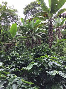
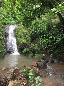
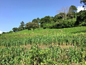
Photos from work in the northern coffee-growing regions showing, from left to right, a complex shade coffee plot, a community water source, and corn production within a milpa production system.
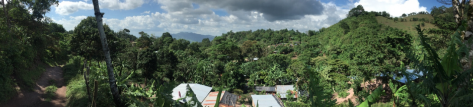
One quick reaction is that I can’t remember the last time I saw such a beautiful and complex landscape. Pine-oak savannahs and silvopastoral grazing systems along Nicaragua’s dry corridor, maize-bean milpa systems, complex shade coffee and high montane forest. One of my roles in the project will be to document recent land use and cover change to provide cooperatives in the region with one tool (of many) they might use in long-term adaptive planning. This fits in with ongoing project research and capacity building efforts to explain patterns of access, property rights, and the use of common environmental resources as a key individual and collective action strategy for securing food and water. My visit reinforced how complex land use mapping will be in the high montane coffee-growing regions of the northern Nicaragua. Not only do the mountainous slopes (and persistent cloud cover) confuse the task, but the vegetation is complex and diverse. Differentiating between shade coffee and intact forest will be particularly difficult. Many coffee plots are nearly indistinguishable from forest even when examining high resolution QuickBird imagery (and even when looking up at the canopy while walking within them). We began work to circumvent this challenge on the trip by collecting geolocated land use data to train an eventual classification algorithm, working alongside cooperative leaders with intimate knowledge of the landscape.
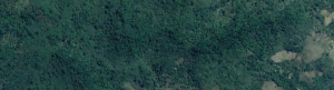 1m resolution Quickbird imagery as viewed within Google Earth Engine. This image captures a mixed montane forest-shade coffee landscape as well as several milpa plots to the far right.
A set of reflections that will take me longer to work through are those concerning the specific actions people are already undertaking to cope with and adapt to existing threats they confront. In the region, these include the outbreak of coffee leaf rust or la roya and the most severe drought in the past thirty years. Survey data developed and collected by project PIs and promotores will help get at this; providing longitudinal perspective on household strategies and experiences in both 2014 and 2017. So will focus group discussions, interviews and historical-comparative ethnographic research. My recent trip reminded me however that smallholders are often confronting countervailing dynamics and pressures. For example, despite research in the area showing the apparent benefit of fruit trees for food security, fruit trees compete with roya-afflicted coffee plants for limited on-farm water. Simultaneously, the dense tree cover of complex shade agroforests helps raise on-farm humidity, and potentially, the likelihood of roya outbreak. I’m excited to be working with great project partners in both Nicaragua and California, and looking forward to diving into these complexities further over the next year of post-doctoral research and into the future through comparative work in both Indonesia and Nicaragua.