One of the few things I remember from my Geography class is my teacher showing me different countries on a world map. But as I look back now, I feel I had a very contorted image of the world as a kid and the reason is misrepresentation of world on flat map.
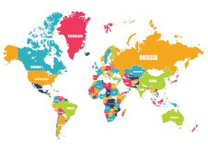
The Mercator Map projection which we all commonly use and are aware of converts circles of latitude and lines of longitudes into straight lines perpendicular to each other which completely distorts the shape and size of the countries especially when you move away from the equator and move towards both the poles.
Imagine a tube around the world:
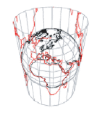
For drawing a flat map, countries are projected on this tube. The poles which otherwise do not touch the tube are on purpose sketched on the tube. Unrolling this tube results in projection of world on x-y plane which completely distorts the Y plane.
When a kid sees this map, he tends to imagine the world and size of each continent with respect to other as shown in the map and create a flawed mental picture.
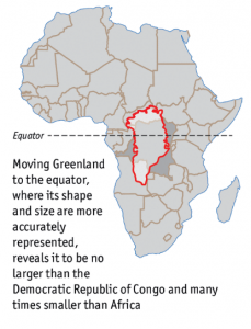
For instance, Greenland (which lies on the North Pole) is interpreted approximately the same size as that of Africa but the fact is Greenland is just as big as Congo (which is just a small part of Africa). Moving Greenland to equator (as shown in below diagram) reveals that Africa is almost 14 times larger than Greenland.
 It was only after research and travelling, I got to learn about real shapes and sizes of various continents but there might be many students who leave school with such wrong perception caused due to poor visualization.
References:
Google US. 2017. world map – Google Search. [ONLINE] Available at: www.google.com [Accessed 23 January 2017].
The Economist. 2017. Daily chart: Misleading maps and problematic projections | The Economist. [ONLINE] Available at: http://www.economist.com/blogs/graphicdetail/2016/12/daily-chart-1. [Accessed 23 January 2017].
Very interesting approach. I think most of us mislead by some type of poor visualization when we were young. Whoever creating those visualization for kids education should be aware of this problem and put themselves in kids shoes to think about how to make better world map visualization so that kids can understand the world geographic better.