
From a handful of dilapidated adobe buildings flanking the Mission Church to our current 160 acres featuring state of the art academic, athletic, and student housing facilities, our winter exhibit Mapping a University: Visualizing the History of SCU’s Campus tracks the steady expansion of Santa Clara University’s campus over the last 175 years. The exhibit, curated by Archives Specialist Kevin Leary, features maps, photographs, and artifacts from the University’s Archives and Special Collections that tell the story of our University’s growing physical footprint, and the measures that University leaders have taken to account for increases in student body, faculty, and programs throughout the years. The exhibit will be on display on the third floor of the University Library until March 22nd, 2026.
A Church on the Move
It’s only fitting to start a conversation about the campus of Santa Clara University by talking about the Mission Church. From the earliest days of Santa Clara, the Mission Church has stood as the central landmark of campus. However, the Mission pre-dates the school by nearly seventy five years, and the church itself has sat in five different locations between its founding in 1777 and the construction of the first church in the current location in 1825.
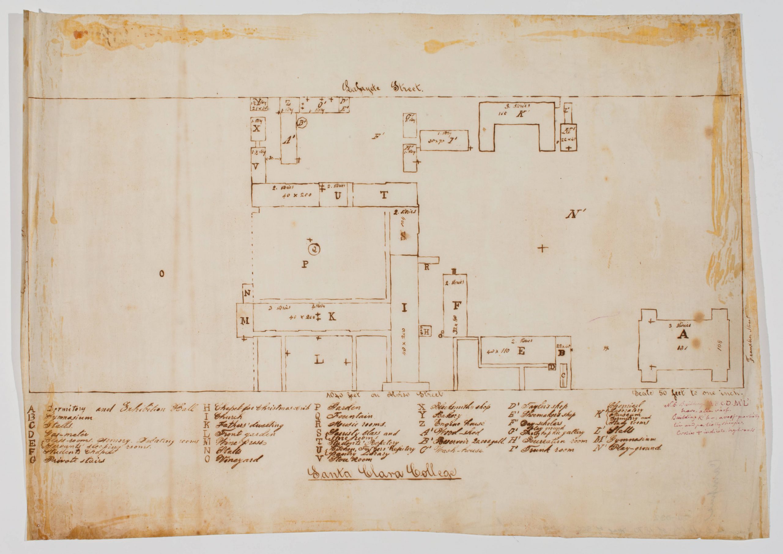
Hand drawn map of Santa Clara College campus, 1870, unknown creator. SCU Digital Collections.
Early Days
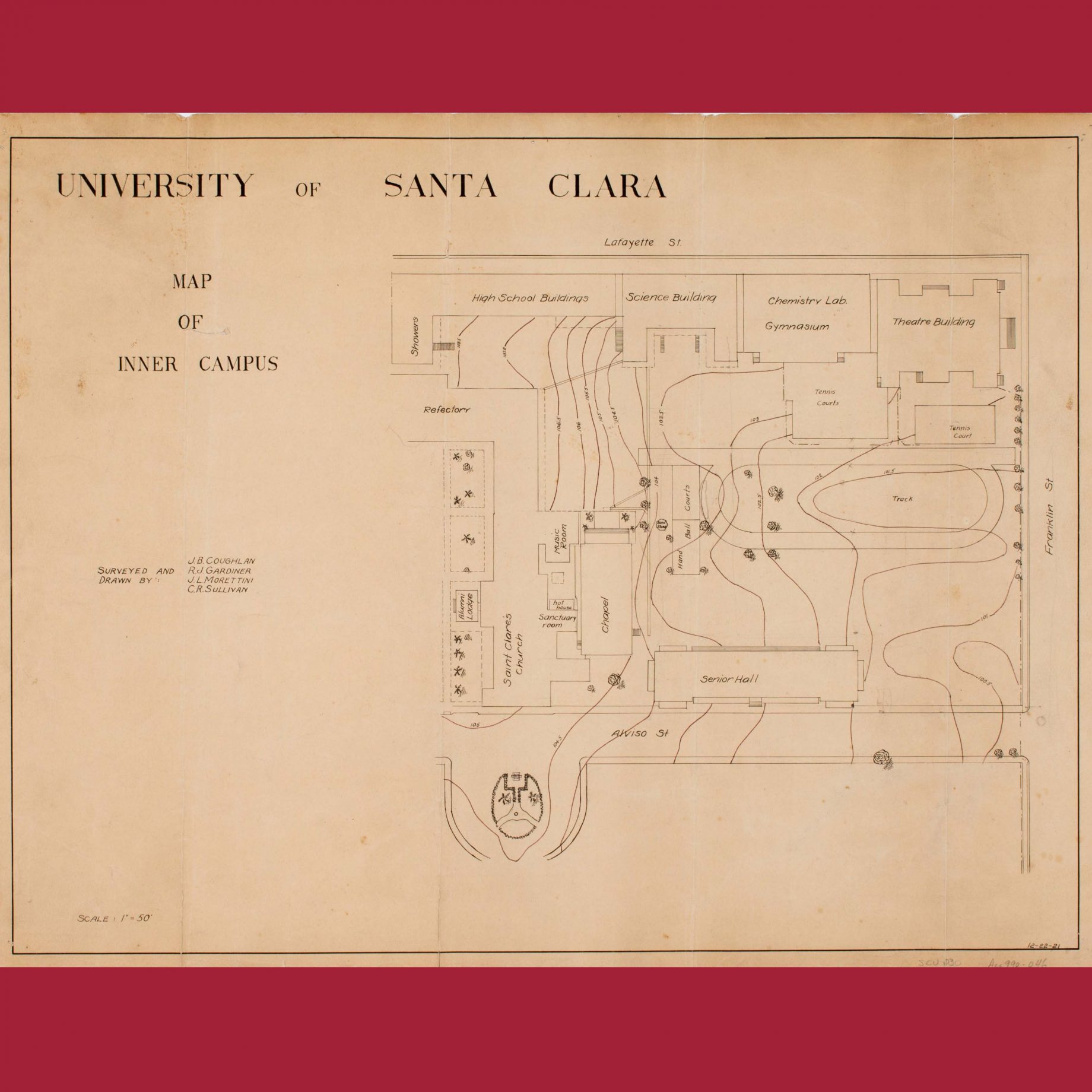
One of the earliest maps of Santa Clara College shows a modest campus by today’s standards. The hand drawn map of the buildings and grounds bordered by Lafayette, Franklin, Alviso, and Lexington streets illustrates the vision set forth by Fathers John Nobili and Michael Accolti, the founding Jesuits of Santa Clara College, nearly twenty years after the school’s first students sat down to study. Establishing the campus was no easy task, with property ownership disputes, people taking advantage of squatters rights, and budgetary restraints all acting as hurdles for Nobili and Accolti to surmount as they tried to buy up the lands surrounding Mission Santa Clara (see McKevitt, 1979). By 1870, 14 years after Nobili died from tetanus after stepping on an exposed nail in the brick chapel he was constructing, the properties owned by the college included the Mission grounds, a lodging building next to the Mission Church called the California Hotel, and some alfalfa fields and farm buildings on the other side of Alviso street. Lafayette remains the western limit of campus, but since 1870 the University’s footprint has extended well beyond Franklin, Alviso, and Lexington. Eventually, the aforementioned alfalfa fields would house the school’s athletic fields and in-ground swimming pool, and in the early 1950s the school would purchase more properties on that side of Alviso street to account for growing demands from an influx of students returning from the second World War.
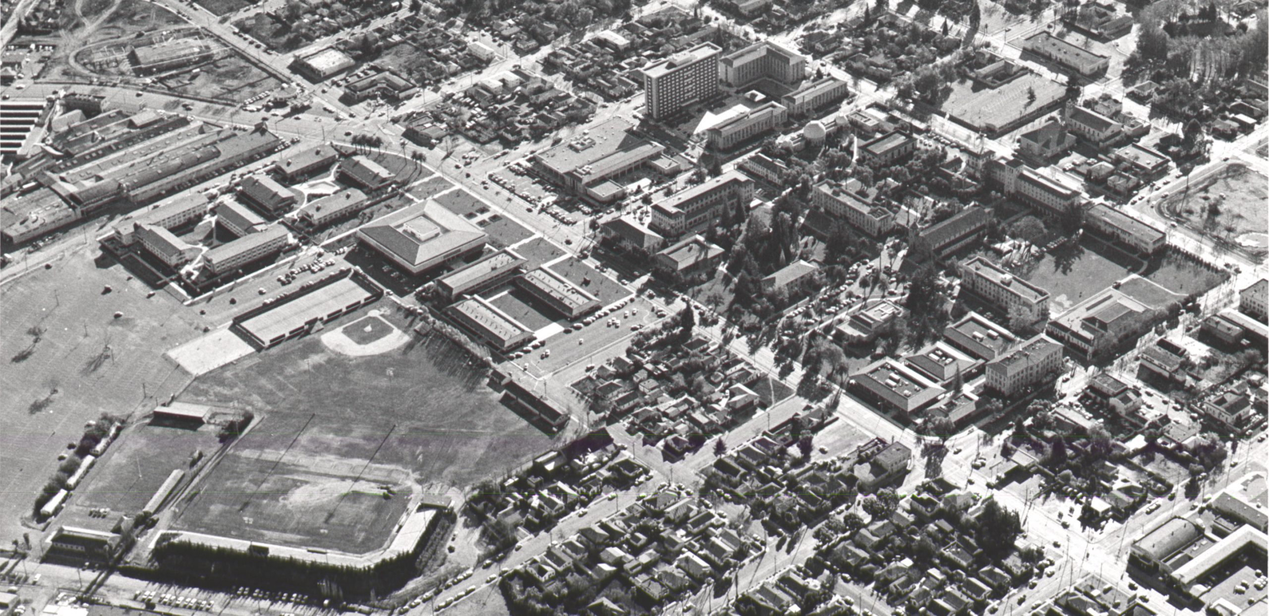
Aerial photograph of Santa Clara University Campus in the 1970s, with the main campus in the top right and Buck Shaw Stadium in the bottom left. SCU Campus Views Photograph Collection, Box 1, Folder 5, Aerial 1975.
Shattering Traditions and Planning for the Future
The 1960s was a decade of change at Santa Clara University. The decision to go co-ed in 1961 allowed women to enroll in all available undergraduate programs. This decision, along with increases in funding and an expansion of faculty and academic programs, led to a dramatic jump in enrollment. The student body grew from just 1,500 to over 5,000 over the next ten years, necessitating more housing, academic spaces, and administrative offices (see McKevitt, 1979). The expansion led by President Donahoe would see eleven new buildings added to campus, including dormitories, academic buildings, and a library, as well as Buck Shaw Stadium. This is when campus started to take on a more familiar shape and resemble what we know it to look like today. Over the next 65 years a handful of buildings (mostly athletic) would be added, and the 1988-1989 re-route of The Alameda cemented the footprint of the campus we now call home.
Works Cited & Credits
McKevitt, Gerald S.J. The University of Santa Clara: a History. Stanford University Press, 1979. SCU Library Catalog Record.
We have many, many more historic maps and photographs of Santa Clara University, including a digital collection of SCU Maps and the physical SCU Campus Views Photograph Collection. For more information about the exhibit or the related collections at the University Library, Archives & Special Collections Department, please contact specialcollections@scu.edu.
Exhibit and blog post by Kevin Leary